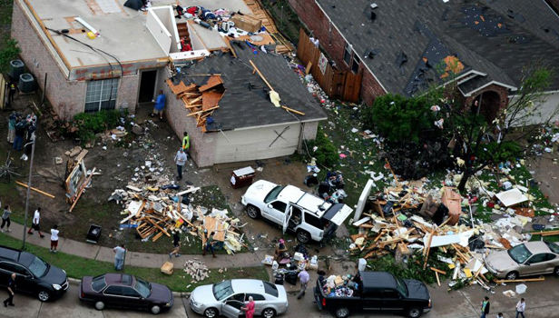
The Tornado forced the Mayor to declare a state of Emergency
“I have never seen two tornadoes hit two large metropolitan areas at the same time before,” Expert Senior Meteorologist Henry Margusity said. According to FlightStats.com, all American Airline Flights at the Dallas International Airport are cancelled.
This image of a tornado touching down was taken from the Texas Department of Transportation web camera along I-35 in Parkerville, Texas. Arlington, Texas, was hit very hard, forcing the mayor to declare a state of emergency.
Homes were heavily damaged in some communities, while trees and power lines were toppled. Gas leaks occurred in some parts of Arlington. Currently, storms are gathering into a squall line from Paris to Austin, Texas. The main threats with these storms are transitioning to large hail and damaging winds. However, some discrete thunderstorms firing out ahead of the main line of thunderstorms moving from northeastern Texas into southwestern Arkansas, far northwestern Louisiana and far southeastern Oklahoma could still spawn tornadoes.
4:45 p.m. CST: Emergency Manager reported a possible tornado east of Hagansport in Franklin County, Texas.
4:32 p.m. CST: A large and dangerous tornado was spotted south of Greenville, Texas.
4:27 p.m. CST: “Six homes damaged to the point of uninhabitable on Thorn Hill Drive,” Arlington #scanner
4:10 p.m. CST: Titus County Sheriff witnessed a tornado touch down 5 miles northeast of Mount Pleasant, Texas.
4:08 p.m. CST: County Emergency Management reported a tornado near Union Valley.
4:05 p.m. CST: A tornado was reported in Sulphur Springs, Texas.
4:04 p.m. CST: Roofs were torn off of multiple single story homes — from spotter near Lancaster, Texas.
3:42 p.m. CST: A tornado was spotted in Forney, Texas. There are unconfirmed reports that Forney High School was struck by the tornado.
3:15 p.m. CST: Dozens of planes being inspected for hail damage at Dallas International Airport from local news.
3:09 p.m. CST: @spann: Tornado reported on the ground north of Lone Oak, Texas, by NWS.
3:04 p.m. CST: “Highest tornado risks now are near Plano and Wylie. Also circulation seen at Grand Prarie and just south Dallas,” @spann
3:01 p.m. CST: @weathermatrix: Police: Tornado on the ground near Trinity Mills & Tollway in Carrolton, TX
2:52 p.m. CST: “Damage to the house of an elderly couple. Neighbors could not get a hold of them,” Arlington scanner #tornado
2:37 p.m. CST: @JonathanDBoles: Crazy video just happened!! Tornado – Arlington, TX
2:33 p.m. CST: @MadStormChasing “Tornado damage to roof of well-built house in Arlington, TX”
2:23 p.m. CST: Up to baseball-sized hail falling north of Irving, Texas.
2:21 p.m. CST: “Tornado #3 is going to pass very close to Texas Motor speedway,” @wxbrad #nascar
2:20 p.m. CST: “Traffic advisory issued — highway near Dallas, Texas shut down due to tornado, ‘numerous’ vehicles damaged,” @ProducerMatthew
2:13 p.m. CST: @jimwxgator: DFW airport is sending terminal passengers into storm shelters due to tornadoes tracking towards the airport.
2:11 p.m. CST: “A house completely demolished, gas leak in the area” Arlington Police scanner #tornado
2:08 p.m. CST: “Lots of debris and damage to multiple houses in this area,” Arlington scanner #Dallas #Tornado
2:04 p.m. CST: Tornado is heading right toward DFW airport. That could be a disaster.
1:58 p.m. CST: “Motor home blown sideways blocking the street. There is a person stuck inside the mobile home,” Arlington scanner #Dallas #tornado
1:52 p.m. CST: @Henry_Margusity: The storm by Arlington looks like strongest of the two storms now. #tornado
1:44 p.m. CST: @JKnoll52: trucks destroyed pic.twitter.com/yIvIbAfl
1:43 p.m. CST: @ProducerMatthew: Dallas County authorities reporting injuries to residents following tornado (scanner)
1:40 p.m. CST: Tractor trailer being tossed in the air from the #dallas tornado” pic.twitter.com/2IScc0au (via @MikeMasco)
1:39 p.m. CST: A tornado is moving right through downtown Arlington, Texas. This is a very dangerous situation.
1:38 p.m. CST: @ProducerMatthew “LIVE AUDIO: Arlington fire and police scanner bit.ly/hOkQPb
1:36 p.m. CST: @JKnoll52: multiple semi trailers picked up and just tossed. Eastern Dallas County “Tornado Emergency”
1:23 p.m. CST: “This is a potential disaster for east Dallas as the tornado is tracking straight north toward Dallas,” @Henry_Margusity.
1:17 p.m. CST: @Henry_Margusity: Tornado on the traffic cam along I-35 in Parkerville, Texas, near Fort Worth. ow.ly/i/xSCk
A slow-moving storm system centered over northern New Mexico is the culprit behind the severe storms. This system will be slow to inch its way towards the southern Plains by Wednesday morning.
In a setup more typical of late spring or early summer, unusually warm and moist air will continue to surge northward across the southern Plains, the Tennessee and Ohio valleys, acting as the fuel for storms.
With the peak of the severe weather season across the southern Plains occurring during the month of April, it comes as no surprise that the region is under the risk for severe storms.
Similar to Monday evening’s storms that crawled through the Texas Panhandle as well as western Oklahoma and Kansas, the primary threat with today’s storms will be hail.
Some of the hail will be very large, in some instances bigger than the size of golf balls. Hail of this magnitude can cause damage to automobiles, rooftops and even vegetation.
Strong and potentially damaging winds will also be associated with these storms today. Gusts with the strongest storms are likely to exceed 60 mph, which is strong enough the knock down tree limbs.
A few isolated tornadoes will be possible as well with the strongest storms.
The severe storms across the southern Plains are most likely during the afternoon and evening hours as a line of nasty storms slowly progress towards the east. Cities that will be at risk include Tulsa and Oklahoma City, Okla., as well as Dallas, San Antonio and Tyler, Texas. The severe threat is expected to continue into early Wednesday morning as the line of storms pushes eastward into Houston, Texas, Shreveport, La., and Fort Smith, Ark., as well as southern Missouri.